Syenite Lake Project
- 58 cell property 100% owned ~11.6sqkm
- Ties into Transition Metals Maude Lake property to the east and Panther Metals Little Bear project to the South
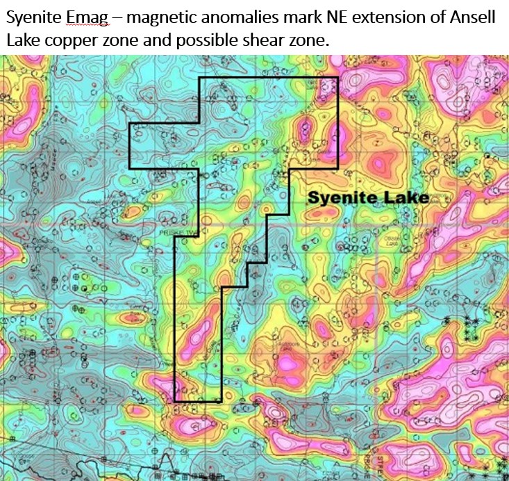
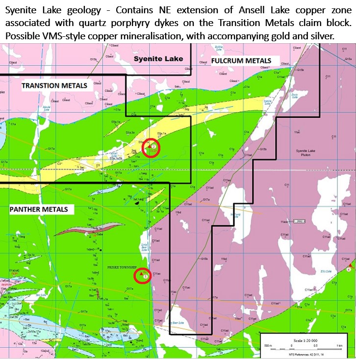
- Contains NE extension of a wide Copper zone on the Transition Metals claim
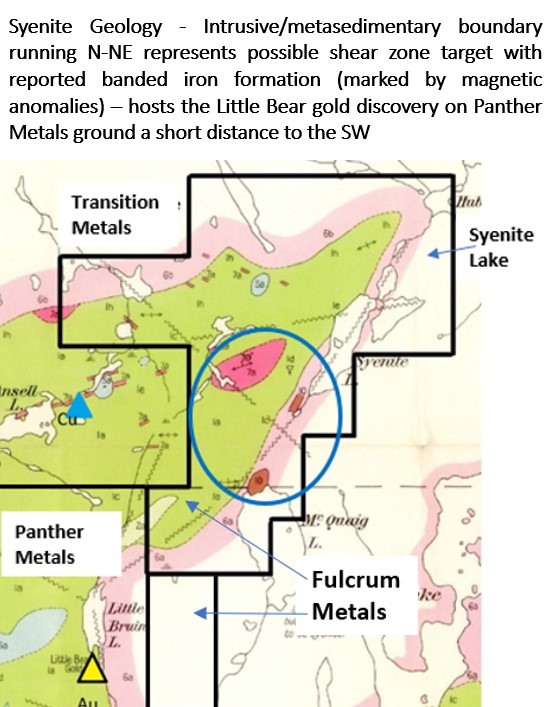
- There are three banded chert-magnetite iron formations, with associated quartz porphyry dykes, mapped within the Syenite Lake property. There is no record of exploration covering these high priority targets
- The Ansell Lake Copper-Silver Occurrence lies just 1 kilometre from the property and the EM conductor associated with this mineralization continues across the Syenite Lake property a further kilometre in distance.
The 48-cell Syenite Lake Property is located 7 kilometers north-east of the town of Schreiber, Ontario and covers an area from Hub Lake in the north to McCuaig Lake in the south. The property is most readily accessible by air. Helicopter access is facilitated by Wilderness Helicopters stationed in nearby Marathon, Ontario. The nearest lake suitable for float-equipped aircraft is McCuaig Lake.
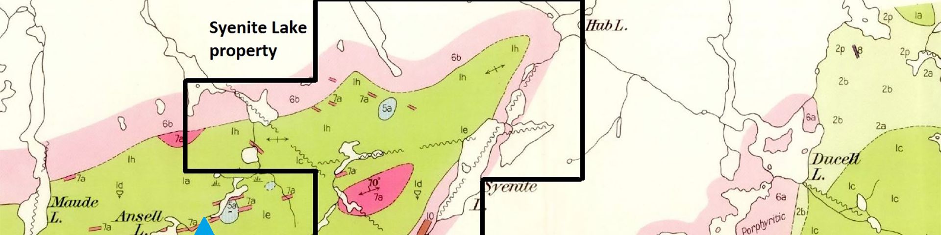
The property is underlain by a steeply dipping, ENE trending (60°- 75°), cyclical, Archean metavolcanic sequence which also includes interflow chemical metasedimentary horizons. This metavolcanic sequence is dominated by dark green to greyish, fine-grained, massive flows of mafic to intermediate composition. Medium to coarse volcaniclastic horizons are also present. The dacites are a quartz bearing phase of the andesite and contain clear quartz phenocrysts. Fine to medium-grained mafic volcanics, previously mapped as diorite, may be in part gabbroic. Generally the north portion of the property is underlain by massive mafic flows while the southern part is characterized by vesicular-amygdaloidal mafic volcanics. Metamorphism is of greenschist to lower (garnet) amphibolite grade. The transition from massive to amygdaloidal mafic flows is marked by an increase in disseminated sulphide mineralization, as well as banded chert-magnetite iron formation and chert interflow horizons.
Felsic metavolcanics occur as a series of narrow flows about 60 meters in thickness and consist of buff, tan, grey or dark brownish-grey, aphanitic to fine grained, porphyritic to massive flows of dacite-rhyolite composition. These felsic rocks may be, in part, volcaniclastic and are generally characterized by 1-3% fine, rounded, blue or grey quartz phenocrysts. Small-scale secondary structures such as foliation and small shears are generally oriented ENE sub-parallel to stratigraphy. Joint systems fall into sets which are oriented at 330° and 70°. Indicated faults generally trend in northerly and easterly directions.
The syenite stock that covers the eastern part of the property is quartz bearing and grades into granite. It is massive, medium grained, pink and weathers to a pinkish gray.
Mineralisation appears to be spatially related to mafic-felsic volcanic contacts and is most evident as stringer and coarse, patchy, secondary, open-space infills within variably sheared-fractured or faulted brecciated mafic metavolcanics. Wall-rock alteration consists of fairly strong, widespread chloritization with isolated, variable silicification and sericitization. Chlorite-rich mafic metavolcanics near the Ansell Lake Copper Occurrence on the adjacent property owned by Transition Metals, are marked by a spotted-hornfelsic texture in which chlorite porphyroblasts (retrograded cordierite) occur in a hornfelsic groundmass. This feature is similar to pipe-like, footwall alteration within mafic volcanics which underlie several volcanogenic massive sulphide deposits (most notably Millenbach) in the Noranda area. (Todd Sanders, Flint Rock Mines, 1985).
1921 - Unknown explorers put down several pits in the area of Ansell Lake.
1950-54 - East Sullivan Mines/Ascot Metals identified significant volcanic hosted sulphide mineralization within sheared andesite at the contact of a porphyry body (Ansell Lake Occurrence). Ascot chip sampled surface trenches and the assays returned 1.06% copper across 14.3 meters including 0.01 oz/ton gold over 9.1 meters and 0.40 oz/ton silver over 4.6 meters. Ascot drilled three holes (totaling 305 meters) in the vicinity of the Ansell Lake Occurrence. Assay values in diamond drilling indicated 0.6% copper and 0.3 oz/ton silver over 3.0 meters as well as 0.4% copper and 0.2 oz/ton silver over 6.1 meters.
1983-85 - Flint Rock Mines performed sampling, prospecting, line-cutting, EM and mag surveys.
1988 - Ansell Lake Resources cut 40.7 kilometers of line and performed a magnetometer survey, VLF-EM survey and Induced Polarization survey. They drilled five holes in 1989 for a total of 649 meters.
There has been no exploration in the area of the McCuaig Lake property since 1989.
Mapping in the area of the Ansell Lake Copper-Silver Occurrence has defined disseminated to semi-massive sulphide mineralization indicating a significant potential for volcanogenic copper-zinc mineralization. There are three banded chert-magnetite iron formations, with associated quartz porphyry dykes, mapped within the Syenite Lake property. There is no record of exploration covering these high priority targets. The Ansell Lake Copper-Silver Occurrence lies just 1 kilometer from the property and the EM conductor associated with this mineralization continues across the Syenite Lake property a further kilometer in distance.