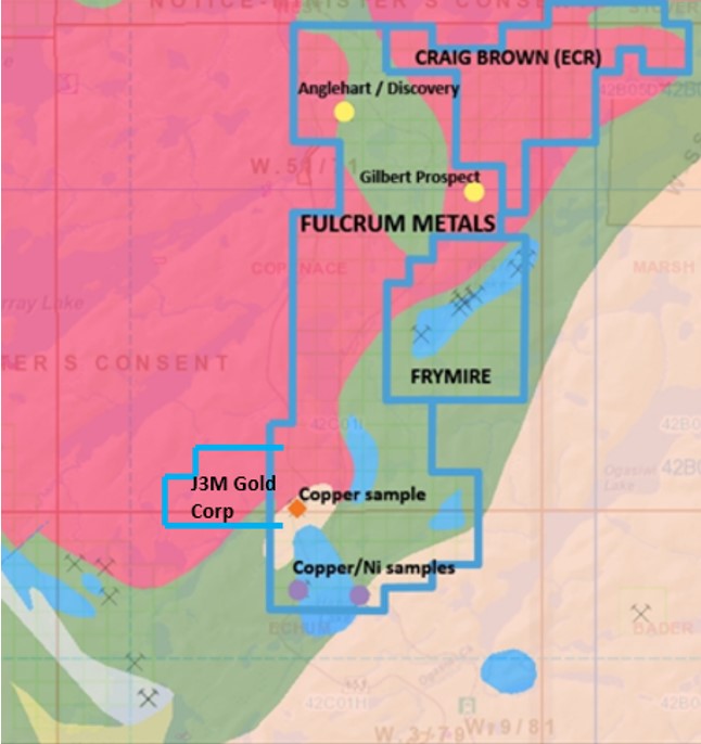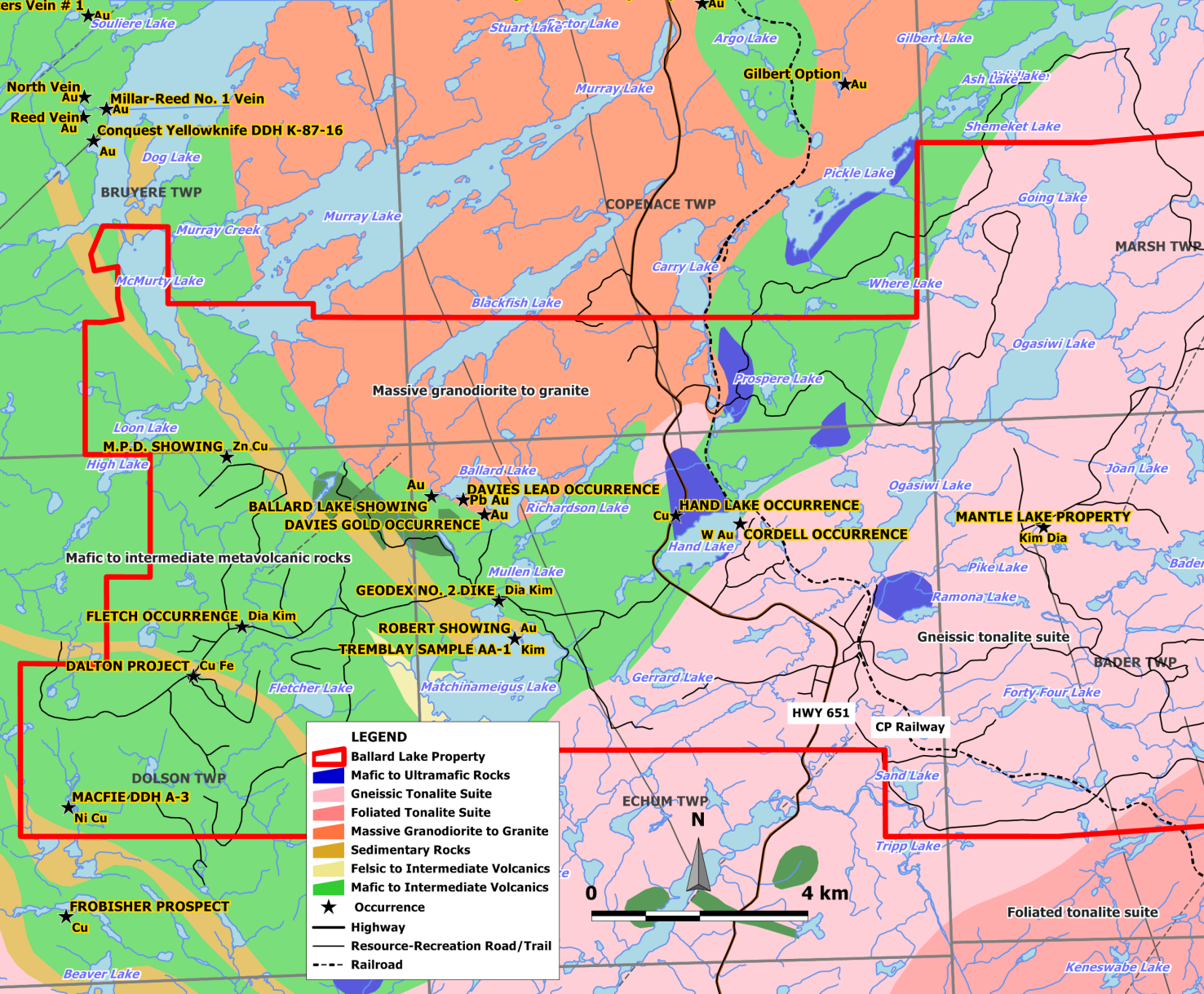
Dog Lake Project
- Consists of a contiguous block of 154 mining claim cells (~25sqkm)
- In the underexplored Michipicoten (Wawa) greenstone Belt.
- Excellent access.
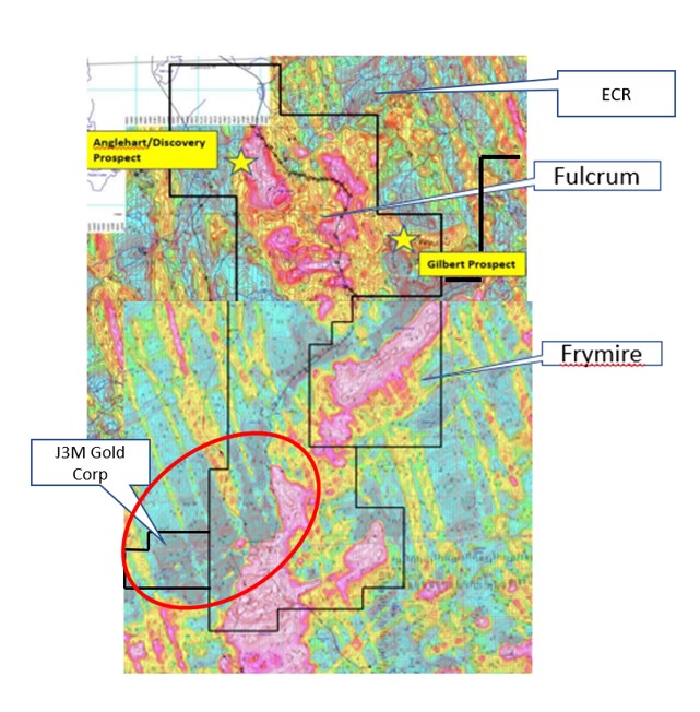
- Abuts newly staked land by Craig Brown (ECR) and Frymire property (with numerous Nickel targets with samples 3000-4000ppm Nickel).
- Historic gold showings, Gilbert up to 3.73g/t, Discovery prospect up to 5.2g/t and Anglehart prospect up to 1.9g/t.
- A random roadside soil sample by OGS identified Cu 3474ppm.
- The Discovery Prospect (faulted quartz stockwork zone) has a significant linear extent and the alignment with a N-S magnetic boundary could be significant.
- The Southern point of the property has similar Ultramafic geological markers along Carry Lake to Frymire property.
- Features a number of Breccia targets suggesting hydrothermal alteration.
- At least 2 EM conductors east of Gilbert prospect.
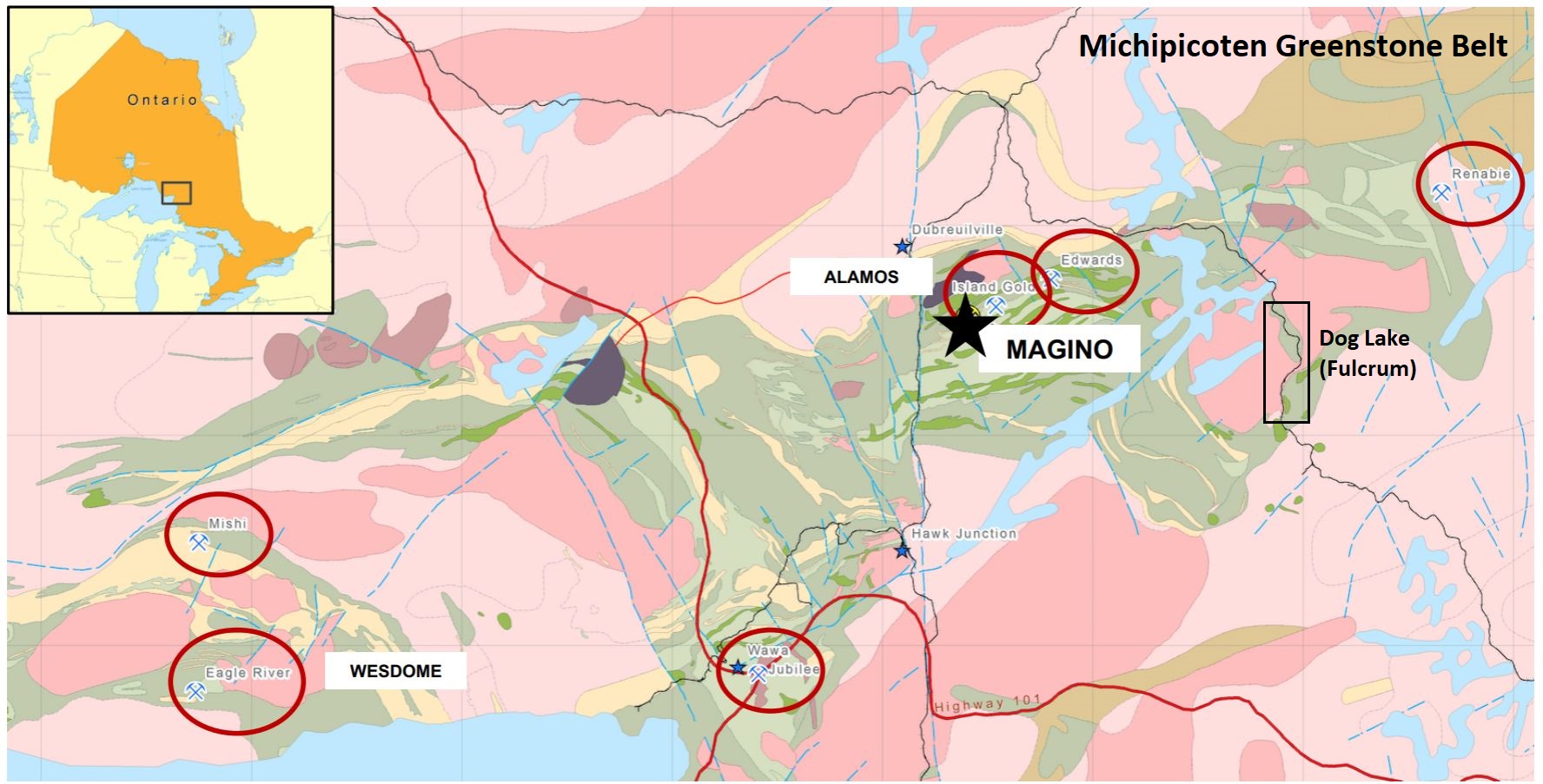
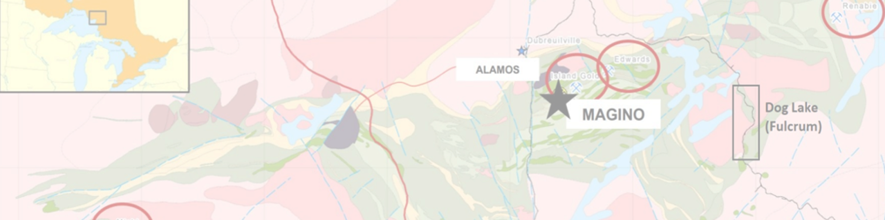
The Dog Lake property is located on the southeastern limb of the Michipicoten Greenstone Belt. The Michipicoten greenstone belt extends inland for approximately 150 kilometers from the Lake Superior shore, with an average width of 45 kilometers. The region has produced over 3 million ounces of gold since the start of the first gold rush in the late 1890s. The belt has a long history of past production, but many historical mining sites remain underexplored by modern methods. This belt is home to the Island Gold mine, operated by Alamos Gold, one of Canada’s highest grade and lowest cost gold mines. Further, the Magino project, owned by Argonaut Gold, is currently clearing the site for construction of a mine, with first gold production forecasted during the first half of 2023.
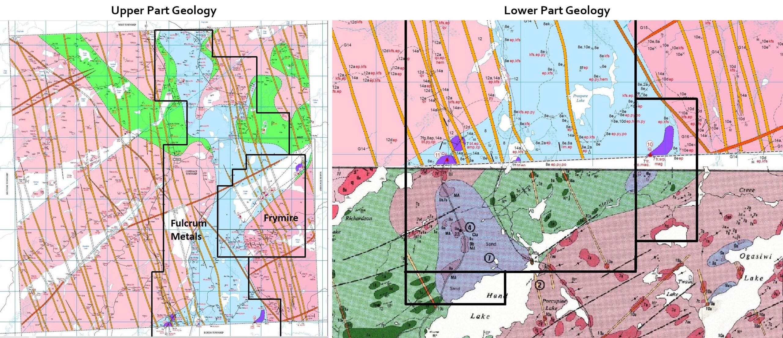
Highway 651 running north from highway 101 to Missanabie cuts through the western edge of the property, while Canadian Pacific Railway line runs through the centre. The village of Missanabie is located a short distance to the north. The property can be accessed on foot from highway 651. The property is underlain by series of east-west trending hills and ridges separated by swamp gullies. Relief between the low-lying areas and hills is approximately 30 meters. Bedrock exposure is good along edges of hills but poor on crests. Average overburden thicknesses are approximately 3 meters and are comprised of sand and clay. Felsic metavolcanics occur as a series of narrow flows about 60 meters in thickness and consist of buff, tan, grey or dark brownish-grey, aphanitic to fine grained, porphyritic to massive flows of dacite-rhyolite composition. These felsic rocks may be, in part, volcaniclastic and are generally characterized by 1-3% fine, rounded, blue or grey quartz phenocrysts. Small-scale secondary structures such as foliation and small shears are generally oriented ENE sub-parallel to stratigraphy. Joint systems fall into sets which are oriented at 330° and 70°. Indicated faults generally trend in northerly and easterly directions. The syenite stock that covers the eastern part of the property is quartz bearing and grades into granite. It is massive, medium grained, pink and weathers to a pinkish gray.
The main geological feature of the area is a southwest trending synclinal belt of metavolcanic rocks in contact with a granitic batholith. The volcanic belt has been intruded by gabbroic and dioritic sills, pyroxenite plugs and diabase dikes. Gold mineralization is known to occur within volcanic terrains, granitic plutons and batholiths and gabbroic sills. Major lineaments trend northeast and to a lesser degree north, northwest. A large lineament can be traced from the head waters of Crooked Lake through the Wawa area to Lake Superior. The property is located along this lineament.
There are several factors that appear to influence the deposition of gold in the area.
1) Gold mineralization of economic proportions occurs within close proximity to the volcanic - granitic contacts.
2) Within the granitic batholith which hosts the Renabie, Niidulama and Braminco ore deposits, gold deposition occurs at the intersection of major shear systems.
3) There is association with gold and smaller felsic intrusions.
4) In several localities there are sills of metagabbro and diorite. Gold is known to occur within these units (i.e. Ballard Lake and Marsh Lake Occurrences and the Kremzar New Zone).
5) There is a spatial relationship of gold and ultramafic plugs.
All the factors described above exist on the Dog Lake property. To date anomalous gold values have been obtained from a variety of geological settings. The property contains two main gold showings, as described below.
Anglehart Prospect
The occurrence consists of a silicified quartz stockwork within mafic metavolcanic rocks. The stockwork strikes roughly north and is roughly 15 meters in width. The main gold-bearing quartz vein has been folded and the fold plunges to the SE approximately 50 degrees. The vein is hosted in a migmatized diorite containing fragments of mafic metavolcanic rocks. The quartz vein might actually be a segment of folded iron formation. Grab samples collected by Anglehart in 1988-89 returned values up to 5.2 g/t gold. Copper values up to 0.22% also have been recovered from the veins.
Gilbert Prospect
The showing consists of a weakly carbonated shear zone lying within altered mafic metavolcanic rocks. The best assays to have been returned from the occurrence range up to 3.7 g/t Au.
The property is host to a large silicified quartz stockwork system. The stockwork system strikes roughly north-south. The zone is approximately 15 meters wide and has been traced for 800 meters. The system is open along strike in both directions. Both showings have seen very limited hand trenching and sampling.
In January, Argonaut Gold announced that it has intersected 10.0m at 19.0 g/t Au, including 6.3m at 30.2 g/t Au and 3.1m at 47.1 g/t Au, including 1.3m at 112.0 g/t Au in the South Zone at its 100% owned Magino property in Ontario, Canada. The South Zone has now been intersected in numerous drill holes extending from the border between the Island Gold mine and the Magino project westward over a strike length of 1.5 kilometres and remains open at depth and to the west. The South Zone follows the contact of the Webb Lake Stock (granodiorite rocks) and volcanic rocks.
The Gilbert Showing at Dog Lake consists of a carbonated shear zone within altered mafic metavolcanic rocks lying about 400 meters north east of the Ash Lake pluton (granodiorite rocks). Whereas the Anglehart showing consists of a silicified quartz stockwork hosted in a migmatized diorite containing fragments of mafic metavolcanic rocks. The pluton/volcanic contact could be important at Dog Lake.
Alamos Gold news release (2021-02-23)
Island Gold was once again the largest driver of global mineral reserve and resource growth in 2020. Despite a smaller-than-planned drill program due to COVID-19, Island Gold more than replaced mineral reserves, and delivered its largest annual increase in inferred mineral resources to date and at significantly higher grades. Mineral reserves increased 8 per cent in 2020 to 1.3 million ounces, despite the primary focus in 2020 being on mineral resource growth. The increase in mineral reserves included the addition of 239,000 ounces, which more than offset mining depletion of 144,000 ounces. Mineral reserve grades decreased slightly to 9.71 g/t Au due to higher grades mined in 2020 (11.18 g/t Au) as well as a reduction in the cut-off grade, reflecting lower expected costs following the completion of the phase III expansion in 2025. Since the acquisition of Island Gold in November, 2017, mineral reserves have increased 74 per cent, net of depletion, with mineral reserve grades increasing 6 per cent.
Argonaut Gold news release (2021-02-25)
Made decision to advance Magino into construction;
Executed a fixed-bid contract for a significant portion of the Magino project initial capital;
Continued to intersect high-grade gold mineralization below and adjacent to the planned pit and identified multiple new high-grade structures hosting multiple veins;
Elbow and Central zones showing promising high-grade gold continuity;
Intersected high-grade gold mineralization in new zones Scotland, No. 42, Sandy and South;
South zone strike length extended to 1.5 kilometres and remains open to the west and at depth;
Completed pivotal permitting milestone with the federal cabinet decision to authorize Schedule 2 amendment;
Obtained key species at risk permit for bat conservation;
Completed a major permitting milestone with the Magino closure plan filing;
Accommodation agreement framework agreed to with Garden River First Nation;
Completed and received authorization for Fisheries & Oceans Canada fish habitat compensation plan.